
Nansemond Natural History & Cultural Reclamation
In genealogy, much of one’s time is spent learning the geographical and historical details of ancestral communities. I have written many articles about life on the Virginia/North Carolina state line, lifestyles, and infrastructure development that transformed the region–but researching these details was merely part of capturing evidence (knowing where to look and what type of records to look for). Throughout this process, I have learned many other details of personal importance that are peripheral to genealogy.
In this article I will share a glimpse of the other side–the natural history of the Great Dismal Swamp and its representation in Nansemond culture. The more one learns about the environment and indigenous inhabitants’ relationship to it, the more natural influences become apparent in modern life. Soil quality, vegetation types, geographic distribution of communities, road names, and more are remnants of earlier times.
From “Fishing Point” to the Great Dismal Swamp
Jim Byrd, a charter member of the Suffolk Historical Society (established in 1966) and chairman of the Suffolk Indian Commission, studied Nansemond people for more than 60 years. While anthropologists of the early 1900s, like James Mooney and Frank Speck, studied the day-to-day lives of the small Nansemond community in Bowers Hill, Byrd studied the large Nansemond community (> 1000 people) prior to and during first contact.
Byrd’s archaeological research and artifact collection provided insight into Nansemond culture at Reid’s Ferry–the primary settlement on the Nansemond River in 1608 when the English settlers arrived. He documented Nansemond proficiency in agriculture and fishing (the word “Nansemond” meaning “fishing point“) and the people’s reverence for the sun. He also described Nansemond displacement from the Nansemond River front (the center of Nansemond settlements up to the early 1600s), to living with the Meherrin and Nottoway (mid-late 1600s to present day), to a small group living on the northern border of the Great Dismal Swamp near Bowers Hill (late 1600s to present day).

The Gallberry Road

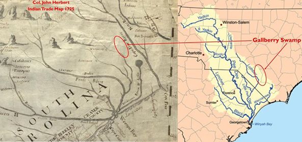
Although the Nansemond moved as a result of displacement from settlements along the Nansemond River, the Great Dismal Swamp was not foreign territory. The cleared swamp land where the Nansemond lived in the early 1700s, which was often referred to in deeds as the “Gallberry Swamp1,” was historically used by the Nansemond as a hunting ground. Interestingly, gallberry is highly adapted to areas with frequent fires due to its widespread subterranean root systems that connect bush-to-bush and enable proliferation on scorched land. Many Native Americans used fire strategically to clear areas for hunting and the presence of gallberry patches on this ancestral Nansemond land was not likely a coincidence.

“The natural growth of this land is: reeds standing very thick, of moderate size, small sickly pine saplings, red and white, bay bushes and gallberry. I have no doubt that this land has been often burnt.” (Page 30)
“The character of the gallberry lands require also new investigation. These have usually been regarded as worthless. They are usually flat and wet, and hence the temperature of the surface is always too low for the vigorous growth of the most valuable trees: aside from this fact it is probable that the soil is really poor and unfertile, and no measures within a reasonable expense could be employed to change this semi-barren condition to one of fertility.” (Page 39)

“Gallberry Road” (a reference to the gallberry swamp) was the name of the road the Nansemond followed from ancestral settlements in Nansemond County, VA just over the county line to Norfolk County, VA and it was also the name of smaller roads that many Nansemond lived along in northeastern North Carolina. An understanding of gallberry sheds light on an aspect of history that would never be captured in colonial records–gallberry patches were familiar grounds to indigenous people, especially hunters (gallberries are a favored food source for bees, birds, bears and a variety of wildlife), yet they were undesirable to agrarian colonists. By the mid-1700s there were Indian settlements around these areas throughout North Carolina.
Gallberry Swamps & North Carolina Indian Communities


This pattern is evident in Indian communities throughout North Carolina. There were displaced tribal people living around gallberry swamps from Halifax County, NC to Cumberland County, NC. The Haliwa-Saponi community, which has Nansemond ancestry (among others), and the Lumbee community, which has Nansemond, Potoskite, and Yawpim ancestry (among others), are both clear examples.
What can be deduced from this pattern? My hypothesis is that gallberry swamp land was attractive to displaced tribal people for at least a few reasons:
- It was familiar as ancestral hunting ground
- Repeated burning made the soil undesirable to agrarian colonists
- This likely made the land more affordable
After decades of increasing displacement, settling on land that was undesirable to everyone else may have been a survival strategy. Clearly, proving this theory would require a significant amount of research but the pattern became so clear I had to at least document it in writing.
The Legend of the Great Firebird
Indigenous hunters were far from the only source of fire in the region. The Great Dismal Swamp, a rich source of peat (a natural fuel for fire) has a long history of persistent peat fires. Some peat fires have anthropogenic origins but they can also start naturally (e.g., through forest fires, lightning strikes, etc.) and once they ignite they can be extremely difficult to extinguish because they burn deep underground.

Large fires in the Great Dismal Swamp have been documented in newspapers around the country. People in surrounding communities lost thousands of dollars in property and suffered the death of thousands of livestock. An unexpected consequence of the fires was that runaway slaves, even some who had been gone for “ten, fifteen, and twenty years,” fled the fiery swamp and returned to their former masters for safety.

Lake Drummond, a natural lake in the center of the Great Dismal Swamp, became the subject of Nansemond Indian folklore due to the prevalence of fire in the area. Oral history told of a great firebird that lived within the swamp on a smoldering nest. Some scientists believe that fire cleared the land of vegetation in the center of the swamp enabling the formation of the lake (i.e., the nest), which means the legend may correspond to actual natural history.

Natural History as a Foundation for Research
As I stated at the beginning of this article, the anecdotes and hypotheses shared here will not enable anyone to name a distant ancestor but they may inspire people to look beyond the constructs of roads, county lines, state lines, and government. We are required to study these man-made entities to document our ancestors but natural history is a means to understand our ancestors.
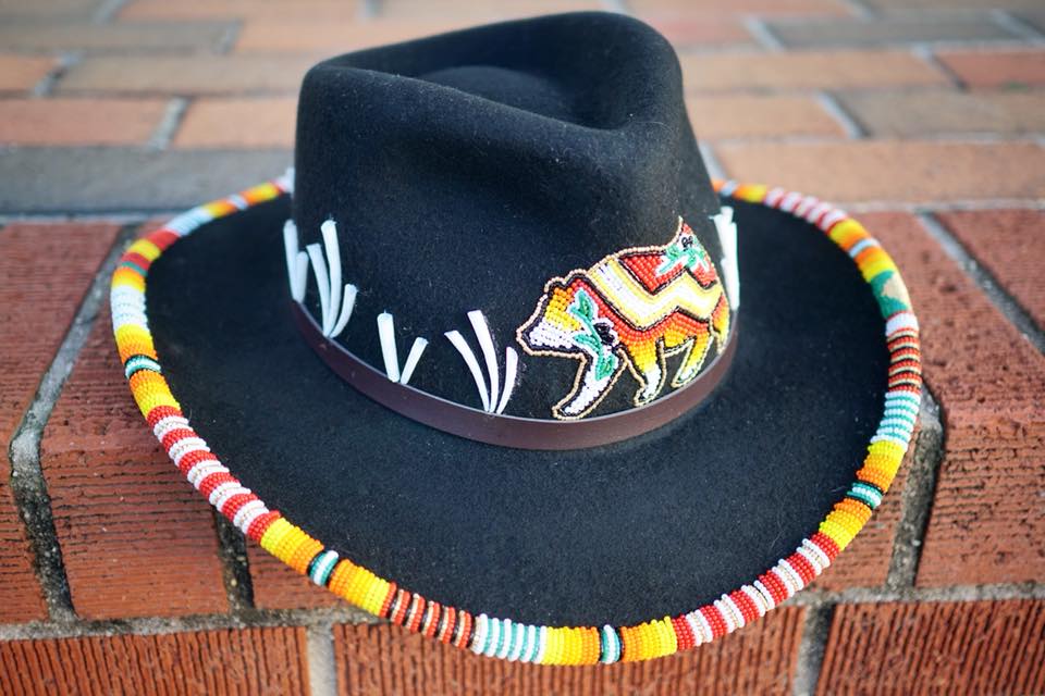
The more I learn about the natural history of ancestral Nansemond land, the more I am inspired to incorporate it into my art. Gallberries are especially inspiring because their deep, extensive root systems enable them to regenerate after fire. They are a subtle reminder of the strength of community and culture. No matter how much of our history has been destroyed we, like gallberry, can always restore it if we remain connected to our roots.
I will continue to share new genealogical information on Nansemond people but I will also return to natural history as frequently as possible as the true foundation for the story of our Nansemond ancestors.

 | Many thanks to Luke Alexander for gallberry swamp land references in southeastern North Carolina. Luke is a family historian for the Benjamin & Edith Spaulding Descendants Association, Inc. with focus on Bladen, Columbus, and Robeson counties in North Carolina. |  |
Footnote
1See Elizabeth Wingo’s “Key To Numbered Place Names,” the 1751-1756 Tithable List. “3. Batcheldors Mill: At the head of Deep Creek where the road to Nansemond County crossed and went through the Gallberry Swamp to Halls Mill.”

Nikki,
This is very nicely done! I thoroughly enjoy reading your work, it is thought provoking.
Great symbolism in your work on the hat!
Best regards,
Tom Badamo
Nansemond
LikeLike
This is a great article, I truly enjoyed reading it!
LikeLike
Enjoyed the whole entire blog I recommend everyone I come Across on the web to stop and read thank you for sharing all this for all of us to enjoy.
LikeLiked by 1 person
Thank you so much!
LikeLike
My Powhatan ancestors were located here (Chesapeake
Bay), on the Nansemond River, a tributary of, in mid 1600s when my first European ancestor (Nathaniel Basse) 8th great grand father) located among them. His holdings (300 acres, crops were tobacco were called Basse’s Choice. His first wife was full blood Nansemond arm of the Powhatan Tribe. His eldest son, John, a half breed, also married a full blood Native America. These unions are registered in the early Virginia-England records and still exist to this day. The tribe also kept the paperwork for their own records. Basse was, of course, an English subject and at that time England controlled him and his holdings.
Note. I have tracked every marriage from Nathaniel down to my great grandfather, Albert Cleveland Holt, in Franklin County Arkansas.
My Aunt has done great research on our ancestry. This is from her. Maybe, it will help.
plquick07@gmail.com is my email, if you or anyone else happens to have anything to add. I’m just learning of this. It is very intriguing to me. Almost, like I already knew it somehow. Weird, anyway. I would like to know more than just this, and what I have researched today after she told me the information above.
Sincerely, Patty
LikeLike
Nikki,
In our continued research about our family, We were pleasantly surprised when we stumbled upon this gem of information. This is very enlightening and helps us to understand the migration patterns of our great granparents and beyond. Well done.
LikeLike
Thank you so much for reading!
LikeLike